New Brunswick Provincial Archives P61-10
Materials required: projector, whiteboard
To begin this class, summarize how Indigenous people viewed, utilised and shared land by summarizing the Teacher’s Notes. Ask the following questions:
- Who lived here first?
- How did they live?
- Who are your neighbours today?
- Are you the same as your neighbours? (consider language, beliefs, ways of living)
- Do you live where your grandparents live (lived) or close by?
- What makes your land belong to you? (occupation, ownership, maintained over time)
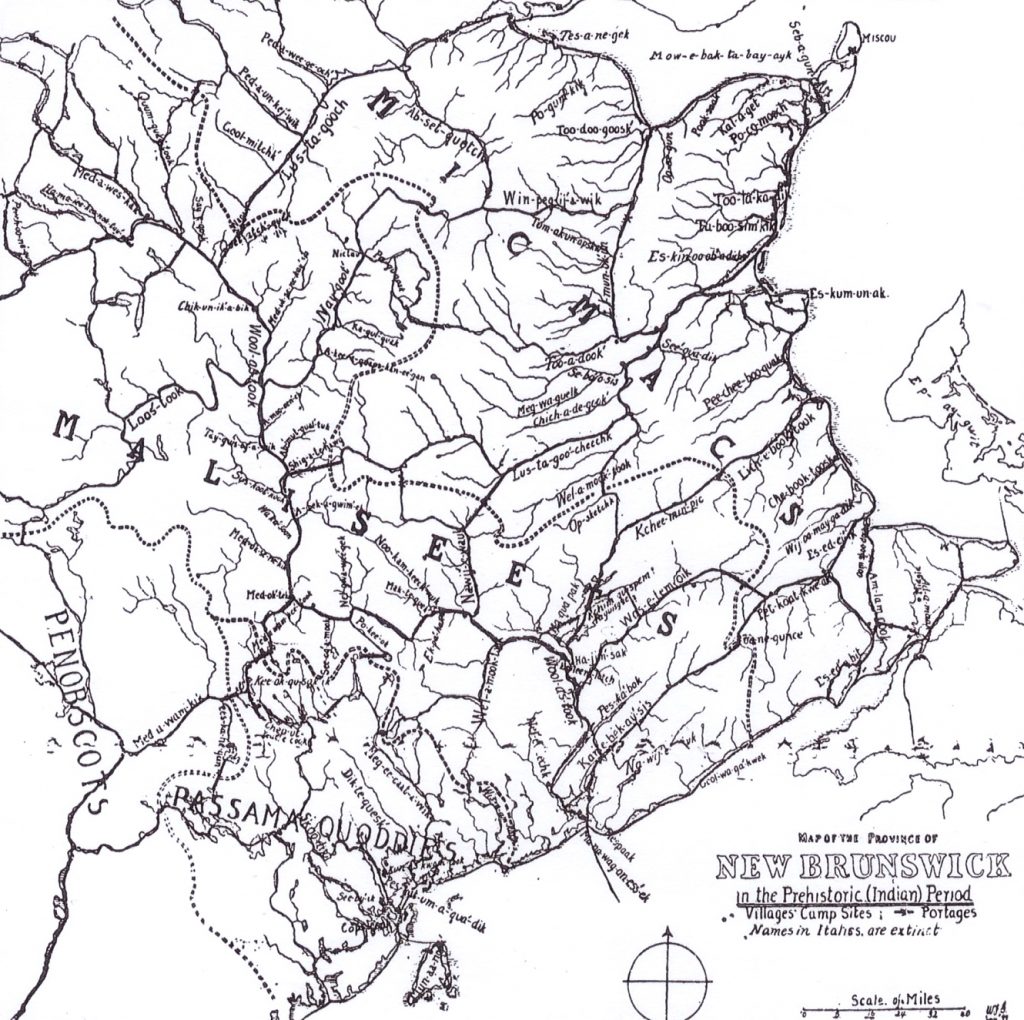
Have students look at the map above. This map was created from a well-known New Brunswick scholar and mapmaker named William Ganong. Ask the students:
- Look closely at the map and find a river, portage, or point of land that is near where you live. Does the river, portage, or point of land still have the same name today?
- If no, what is its name today? Where did this name come from? Research the name online. Why do you think it was changed?
- If yes, is the name spelled the same? Try saying the name the way it is written on the map. Has the pronunciation changed? Search for the Indigenous name online and see if you can find out what its meaning is.
Here are some more modern spellings on a clearer map of Wabanaki names (to project) by: https://www.wabanakicollection.com
Rivers and Waterways: Mi’kmaw Wolastoqey
Oolastook; Wolastoq – St. John River – Beautiful and bountiful river
Neqotkuk – Tobique
Metaksonekiyak – Meduxnekeag River
Kanatawtuk – on or along St. Croix River
Kuspemsis – little lake (Quispamsis)
Lustoq – Aroostook River
Matawaskiye – Madawaska (water flows out over grass or reeds)
Nesuwahkik – on the Nashwaak River (enters St. John River at Fredericton, NB)
Puhkamkesk – at sandy narrows; to, at such a place on the western shore of Schoodic Lake
Mowebaˊktabaak – Baie des Chaleurs – Biggest bay
Lustegooeheechk – Miramichi River
Mijeogun – St. Lawrence River
Nebeltook – Bartibog River – dead river
Mimskoolack – Bass River – winding river
Chigunikpe – Grand Falls – roaring destroying giant
Petkootkweak – Petitcodiac – the river bends round in a bow
Pula mmooa Sipu – River full of salmon
Abegweit – Prince Edward Island – land resting on the waves
Gespeg – Gaspé – where the land ends
Winpepegijooik – Pabineau Falls – a rough stream
Listuguj – Restigouche River
Place Names: Wolastoqey Mi’kmaw
Cemkuk or Kci Putepkik (place of the Great Whale) – Chamcook Mountain near Saint Andrews
Epakuwik – Campobello Island
Eqpahak – old village just upriver from Fredericton, at the head of tide on river
Kci-Oqassutik – in, at, to St. Stephen
Mekikatewik – in, at, to St. George
Menahqesk – Saint John – the place where the sea takes the land
Nekkopahamkek – McMaster Island
Oqassultik – at the landing place on the fine sand is where the canoes go ashore (Grand Manan)
Otuhkelenk – Deer Island
Qonasqiw – Nunanook – Grand Manan – on the point, on the tip
Qonasqamkuk – in, at, to St. Andrews
Sakomawi-Mali – another name for Saint Mary’s (Blessed Virgin Mary)
Walamkuk – Cummings Cove, Deer Island, Welch Pool
Wapatpemikahk – at, to White Head Island, Grand Manan
Wehqayik – in, to Welshpool NB; in, to Oak Bay
Wisawi-mossonkik – yellow birch (Cheney Island, near Grand Manan)
Sebiskadak – Miscou
Sepsgnuncheech – Shippagan – a duck road
Caluget – Caraquet Harbour
Kebmkeak – Bathurst Harbour – stopped by sandbar
Pokumooch – Pokemouche – salt water extending into land
Tulakadik – Tracadie – camping ground
Taboosimkik – Tabusintac – a pair of them
Anigeoeg – Neguac – it springs up out of the ground
Esgemen-ag – Escuminac – waiting point
Pitji-pogeog – Kouchibouguac – standing in
Esedeiik – Shediac – Running far back
Sebelogwokon – Fox Island – where skins are stretched
Elmunakuncheech – Little Sevogle – beaver’s hole


