• Contact us
  • About
  • Contributors
  • TNEGI
  • English
    • Français

Treaty Education Resources

  • Home
  • Grade 3
  • Grade 4
  • Grade 5

Grade 3 – Table of contents

  • Teaching Notes and Approaches
  • Note to Readers
  • Lesson A – Where did we come from?
    Tami wejita’ywkw?
    Tama kilun ktutapeksultipon?
    • Curriculum Outcomes
    • Background Notes for the Teacher
    • Activity 1- How Klu’scap Keluwoskap Created People
    • References
  • Lesson B – All things are related: Interrelationships are celebrated
    Msit koqowe’l akutultikl
    Psonakutomuwakon
    • Curriculum Outcomes
    • Background Notes for the Teacher
    • Activity 1 – About Wolastoq
    • Activity 2 – The Creation of Wolastoq
    • Activity 3A – Mapping Wolastoqey Communities
    • Activity 3B – Mapping Mi’kmaw Communities
    • Activity 4A – Wolastoq (Saint John River) is Renamed
    • Activity 4B – The Sipoq River Song (Listuguj)
    • References
  • Lesson C – We are of the Earth
    Kinu na wskwitqamulti’kw
    Nutapeksipon Nkitahkomikumon
    • Curriculum Outcomes
    • Background Notes for the Teacher
    • Activity 1 – Flag Symbols
    • Activity 2 – Flags to Create Solidarity
    • Activity 3 – Create Your Own Flag
    • References
  • Lesson D – All My Relations
    Ta’n Te’sit No’kmaq
    Psi-te Ntolonapemok
    • Curriculum Outcomes
    • Background Notes for the Teacher
    • Activity 1 – Who Are You?
    • Activity 2 – Extended Family
    • References
  • Lesson E – Life as we knew it
    Mimajuaqn ta’n tel-nenmekip
    Pomawsuwakon Eli-Kcicihtuweqpon
    • Curriculum Outcomes
    • Background Notes for the Teacher
    • Activity 1 – The Many Functions of Water
    • Activity 2 – Keluwoskap (Gal-oo-wos-gob) and the Water Creature
    • Activity 3 – To Dam Or Not To Dam
    • Activity 4 – Mactaquac Dam
    • Activity 5 – Ugpi’ganjig Eel River Bar First Nation
    • References
  • Lesson F – Coming Together
    Mawita’nej
    Mawessultipon
    • Curriculum Outcomes
    • Background Notes for the Teacher
    • Activity 1 – Storytelling
    • Activity 2 – What Is In A Name?
    • Activity 3 – Creating a Landform of your Community
    • Activity 4 – Researching an Indigenous Community
    • References
  • Lesson G – What is a Treaty?
    Koqowey net Ankukumkewey?
    Keq nit lakutuwakon?
    • Curriculum Outcomes
    • Background Notes for the Teacher
    • Activity 1 – Sharing and Showing Respect
    • Activity 2 – Wampum
    • Activity 3 – Create Your Own Message
    • References
  • Lesson H – Your Treaty
    Ktankukumeweymuow
    Ktolakutuwakon
    • Curriculum Outcomes
    • Background Notes for the Teacher
    • Activity 1 – Classroom Treaty
    • Activity 2 – Create a Fair Classroom Treaty
    • Resources
  • Lesson I – We Are All Treaty People
    Kinu na Ankukumkeweye’k Mimajuinu’k
    Psi-te kilun Lakutuwakonicik
    • Curriculum Outcomes
    • Background Notes for the Teacher
    • Activity 1 – We are all Treaty People
    • Resources
  • Resources
  • Interactive Activities
You are here: Home / Activity 3 – Creating a Landform of your Community

Activity 3 – Creating a Landform of your Community

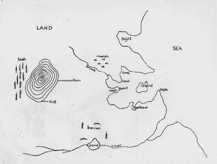
Look at the graph of landforms below and compare it to the landforms which are located on the landform map below. Find your community by using Google Earth. Search to see if there are any landforms that are not listed on this page. In a group, create a landform map for your community using some of the information you have gathered from Google Earth. You can create a three-dimensional map by using plasticine. Colour the land forms on your group map so you can make a legend for your map. If there are names for some of these features (e.g.: Monkey Hill) add them to your map also. If land forms have been altered remove them from the plasticine model or show how they have been altered.

Land Water Coastline
  • Mountain or Hill – a high mass of land
  • Marsh or Bog – swampy places
  • Neck – narrow crossing of land between two bodies of water
  • Bay, Bight, Harbour or Cove – water between two areas of land
  • Pond, Lake – body of water surrounded by land
  • Brook, River, Stream – fresh water flowing from land into the sea
  • Head, Point or Cape – land jutting out into the water
  • Island
  • Beach
  • Cliffs
example of a landform map
Previous Next
×
Government of New Brunswick logo
Office of First Nation Education logo